The River Rye, along with its tributaries of the Seph and Riccal, represent a dynamic catchment landscape that plays host to an impressive array of historic and prehistoric areas of national interest. From the almost invisible prehistoric material culture of the Mesolithic to the imposing medieval remains of Rievaulx Abbey, this landscape has many stories to tell!
Discover the projects we have undertaken to help conserve our shared past and support our future.
N.B. All dates are approximate and not exact.
Mesolithic (10,000 BC – 4,000 BC)
Known as the Middle Stone Age, the British Mesolithic period marked the end of the last Ice Age. Changes in the landscape led to Mesolithic hunter-gatherer-fisher groups exploiting a fast changing environment, where frozen tundra gave way to wooded forests. In the lower lands of the North York Moors and surrounding regions rivers and glacial lakes dominated the landscape, especially in the Vale of Pickering.
Working with DigVentures in 2019, Ryevitalise undertook archaeological field surveys of Snilesworth Moor to find traces of these Mesolithic cultures. Now an open moorland, Snilesworth was once a forested landscape - very different to today. We were able to locate small flint scatters of microliths. These delicate tools, often arrowheads or barbs for spears, are specially shaped flakes of flint used to hunt small to medium sized mammals and fish in woodlands, river catchments and wetlands. They are often the only surviving material culture from this prehistoric and pre-agricultural (or farming) period.

Neolithic (4,000 BC – 2,000 BC)
The Neolithic period sees the adoption of plant and animal domestication via farming as the dominant lifestyle, whilst still using stone tools and flints. This fundamental change in human culture has big impacts on the landscape and how we live, introducing larger settlements, structures and changes in our environment. Stone and wooden henges and monuments appear in the landscape. In the North York Moors area large funerary monuments are raised up and material culture in the form of arrowheads and axes become more evident.
In 2020 we used LiDAR (Light Detection And Ranging) to ‘digitally uncover’ the Ryevitalise landscape. LiDAR is a specialist aerial mapping technique used from the air to ‘see’ through vegetation and our consultant Paul Frodsham guided volunteers on how to use this technique from home. This project, LiDAR Landscapes, saw our volunteers identify numerous previously unknown archaeological sites or structures, once they were referenced against known sites from the NYMNPA Historic Environment Records (HER) database.
Incredibly, a possible Neolithic Long Barrow was identified – a very rare feature in northern England dating from the first farmers. Used as communal funerary monument and as a boundary marker, Long Barrows are a dominant feature in a prehistoric Neolithic landscape. This led to Paul and archaeologist contractor Richard Carlton developing an archaeological survey activity for our volunteers, with kind permission of the landowner. This produced a detailed drawn plan of the site – very useful for future research projects- and enabled the monument to be preserved by record.

Bronze Age (2,000 BC – 900 BC)
During the Bronze Age, farming society becomes the dominant form of lifestyle with the introduction of metal tools and goods. Copper is initially used, before bronze takes over as the prime tool material alongside continued stone and flint. Large scale field systems start to be seen and trade routes are expanded across wider geographic areas of the British Isles and continental Europe using log boats and other crafts. At Danby Rigg, in the north of the North York Moors National Park, a well-preserved prehistoric landscape of cairn fields and dykes can be seen. Alongside these are numerous round barrows and ring cairns, places rich in funerary activity and used for the burial of human remains.
Our LiDAR Landscapes uncovered a number of these cairnfield systems, including near the source of the River Rye and around the Rye catchment area. Although many of these sites are known and recorded in our HER, several were not. These Bronze Age sites are often the earliest recorded human habitation in the Rye area, as population size increased during this period due to settled lifestyles and farming practices.

Roman Britain (AD 43 – AD 410)
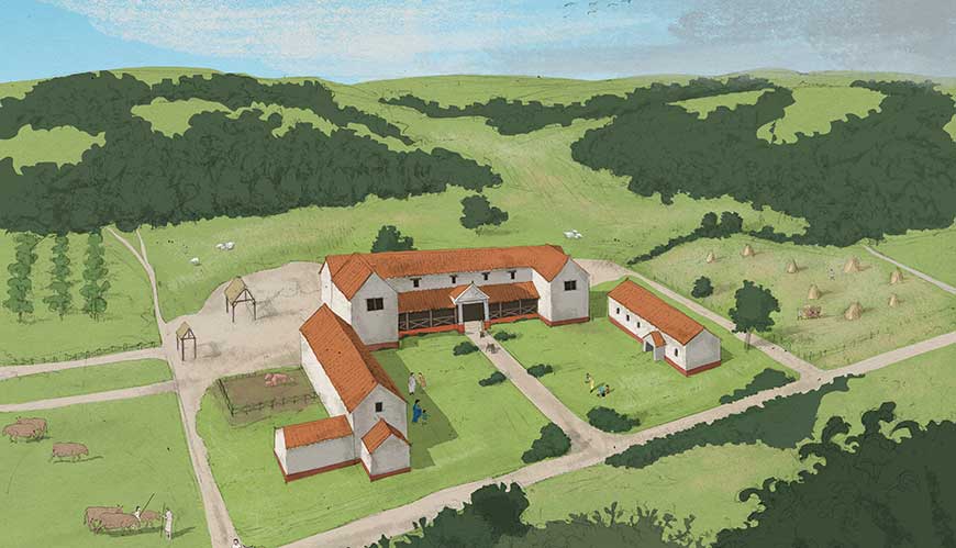
Nearby, York (or Eboracum, as it would have been known at the time), was the centre of Roman life in Yorkshire, but outposts of Roman military and domestic life could be seen throughout the River Rye Catchment area and beyond. The well-preserved Cawthorne Camps are a prime example of military influence in the area, but later smaller domestic sites, such as Beadlam Villa, indicate that not all Roman settlement in the Rye catchment area was military in nature.
Throughout our project Ryevitalise has worked with English Heritage to offer guided tours of their archaeology store in Helmsley, alongside tours of the nearby Beadlam Roman Villa. This 3rd-4th century Romano-British villa is a unique and well-preserved find in the North York Moors; it remains consist of the foundations for three surviving ranges of a multi-family occupied villa. Based on the mosaic found and excavated at Beadlam, and now held in the Helmsley store, we developed a range of exciting activities for local schools. You can learn more about the Beadlam Roman Mosaic on the Out of the box learning website.
Medieval (AD 1066 – 1485) and Post-Medieval (AD 1485 – Modern)
To modern visitors to the River Rye catchment area, the most tangible and physical remains of past societies are the majestic medieval remains of the monastic abbeys, and religious orders who ran them. Yet it is their impact on the River Rye catchment and surrounding landscape that shows their true influence in the area. Rievaulx Abbey, a 12th century Cistercian monastery still partially standing, has been a particular focus of our archaeology and community outreach projects.
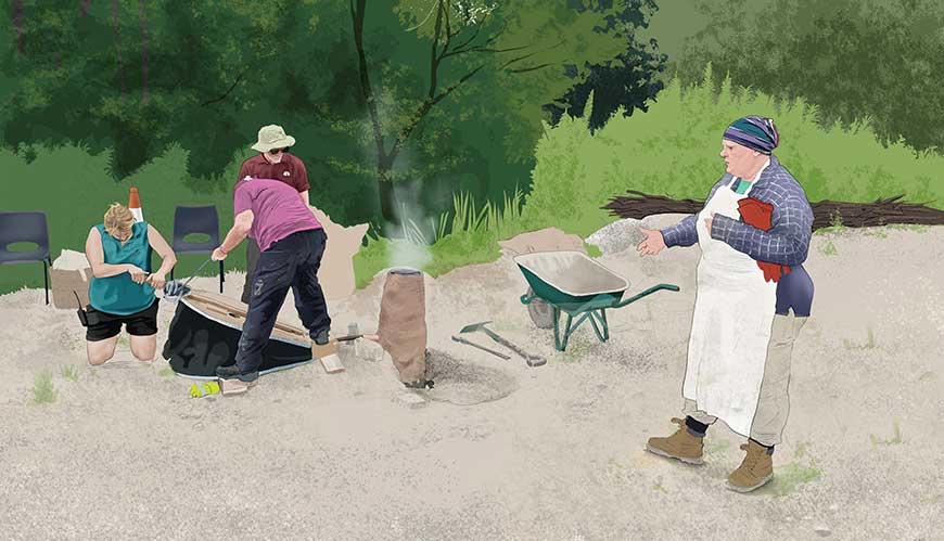
Our ‘A Changing Landscape’ project investigated how the River Rye catchment area was used by these medieval communities in the production and use of iron. Working with archaeologist James Lyall, we surveyed known iron bloomery sites across the Rye and its tributaries using updated geophysical methods and techniques, helping to train volunteers at the same time. We used the extensive data gathered to improve our knowledge and updated the HER database. The second part of this project included an incredible public demonstration of a medieval-style iron bloomery at the Sutton Bank National Park Visitor Centre, courtesy of Yvette Marks from the University of Sheffield, alongside a host of associated crafts delivered by Partners. The hands-on activity included pumping the air-fed bellows, trying a hand at medieval calligraphy, and watching in awe as the blacksmith Katie Ventress worked the red-hot iron bloom produced by Yvette’s experimental bloomery!
At Rievaulx Abbey, the joint English Heritage-Ryevitalise Rye Valley Abbey exhibition explores the impact of the River Rye on the foundation of Rievaulx Abbey. It also demonstrates the effect the monastic order had on the river itself, as they partly subverted the water course for their domestic and industrial needs. As a source of fresh, clean water, the Rye was an invaluable asset in the landscape and this is reflected in the wealth of the Rievaulx landscape and impact its exploitation of natural resources had across the Rye catchment.
The well-preserved Tudor-era tannery vats at Rievaulx Abbey, once used in the foul-smelling job of tanning skins for the leather industry, are currently being restored by English Heritage. Working with Keymer Tile and the North York Moors National Park Authority, Ryevitalise has engaged local school pupils on the importance of sustainability and legacy. Using drawings created by the school pupils themselves, Keymer Tile will stamp new tiles with their designs, and these will be placed in the restored tannery vats as a message for future generations. Winning designs came from Gillamoor Primary School, Chopgate Primary School and Ryedale Secondary School, and we are excited for this legacy to last long into the future.
Working with DigVentures, Ryevitalise explored the development of Ampleforth village using a community-drive Big Dig model. We used numerous test pits in participants’ back gardens and playing fields to track the origin and growth of the village over time. There were many exciting finds, including prehistoric flints, Tudor pottery, and 19th century snuff boxes and clay tobacco pipes. Our public engagement events and booklet distributed throughout the village gave the community a strong sense of engagement and community through a shared sense of history. Find out more on the DigVentures website.
We thank all of the community groups, schools, and partners involved in the projects.
Learn more about the Ryevitalise legacy.
All illustrations are courtesy of the illustrator Nick Ellwood and are copyright NYMNPA.