Getting here and travelling around


Within easy reach of transport links, travel to and from the North York Moors and surrounding area couldn't be simpler. And when you get here, why not let the bus or train take the strain?


Getting to the North York Moors
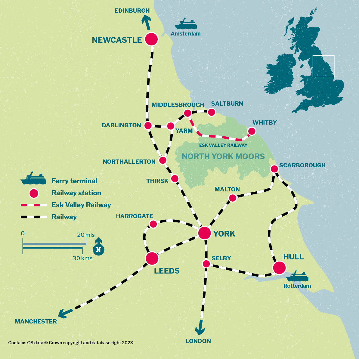
Map showing rail and ferry access routes to the North York Moors area
  The North York Moors are accessible via car ferry at Hull from Rotterdam and Newcastle from Amsterdam from where rail services are available. The area can also be accessed using rail services from Edinburgh in the north via Newcastle and accessed from London in the south. Rail access from the near south, west and south east is available via Manchester, Leeds, York, Harrogate, Malton, Hull and Scarborough. North and eastern rail access is available via stations at Thirsk, Northallerton, Darlington, Yarm, Middlesbrough, Saltburn and Whitby.
  Map © Crown copyright and database rights 2023 Ordnance Survey AC0000813300
Map of rail and ferry access routes to the North York Moors area

The North York Moors is accessible via ferry from Rotterdam to Hull and from Amsterdam to Newcastle where you can pick up rail or bus services.

  • P&O Ferries operates from Rotterdam to Hull. From Hull, you can travel to the North York Moors by train to Scarborough or York and then use the bus network. Plan your journey using the Traveline website.
  • DFDS Seaways also operate ferries from Amsterdam to Newcastle, from where you can pick up LNER. Trains run direct to Darlington, Northallerton and York with connections to Whitby, Malton and Scarborough. Find out more information from National Rail.

Getting around the North York Moors
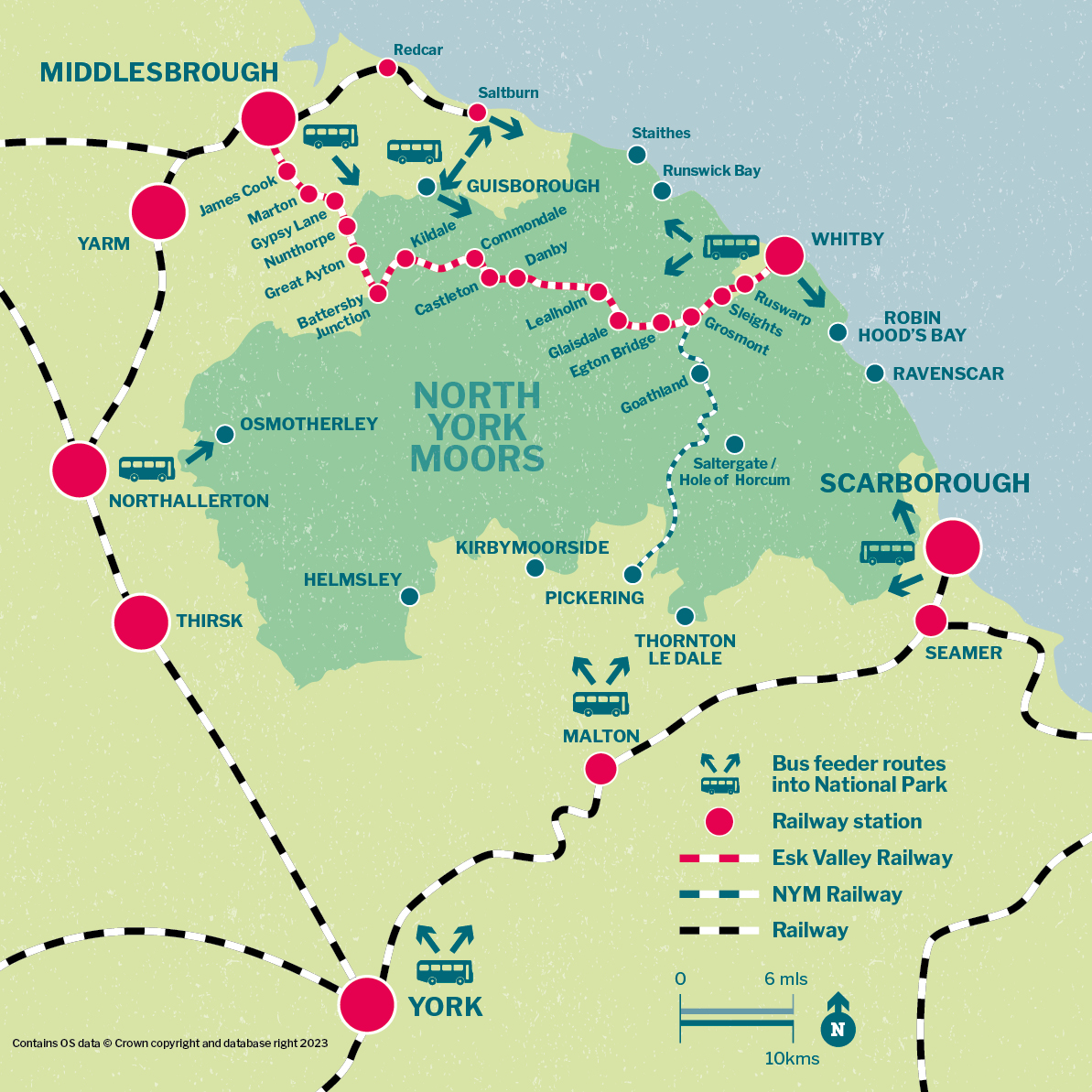
Map showing rail and bus access routes to the North York Moors area
      The North York Moors are accessible via railway stations located at York, Thirsk, Northallerton, Yarm, Middlesbrough, Redcar, Saltburn, Whitby, Scarborough, Seamer and Malton. The Esk Valley railway runs between Middlesbrough and Whitby, with stations at James Cook, Marton, Gypsy Lane, Nunthorpe, Great Ayton, Battersby Junction, Kildale, Commondale, Castleton, Danby, Lealholm, Glasidale, Egton Bridge, Grosmont, Sleights and Ruswarp.
      Access to the North York Moors is also available via bus at York, Northallerton, Osmotherley, Guisborough, Staithes, Runswick Bay, Whitby, Robin Hood’s Bay, Ravenscar and Scarborough.
      Map © Crown copyright and database rights 2023. Ordnance Survey AC0000813300
Map of rail and bus access routes around the North York Moors area

The North York Moors and surrounding area has a good network of rail and bus services, serving many of the main towns and villages, plus some fantastic walking and cycling routes if you'd rather get around under your own two feet (or wheels).

On foot and by bike

Over 1,400 miles of rights of way in the National Park, not to mention forest tracks and quiet moorland roads, walking and cycling are fantastic way to explore, reaching far flung places not possible by car


Buses pass through spectacular scenery and you get the best views from the top floor on double deckers, including on Britain's most scenic route! The key services are listed below, but the easiest way to find the right bus is to use an online travel planner such as Traveline or an app such as Bus Times UK.

Don't forget that most single bus journeys will cost no more than £2 (and only £1 for under 19s) until the end of December 2024.


Share with care

Don't clog up the country roads with your car! Our roads are narrow and shared with walkers, cyclists and horse-riders

View all share with care
Please slow down and drive with care

Please slow down and drive with care

Plan ahead

Plan ahead

Give nature a chance and take your rubbish home

Give nature a chance and take your rubbish home

back to top