

What is the Scoping Report?
A short non-technical summary of this report is available.
This report has been prepared to support work on the new North York Moors Local Plan. This will guide new development across the National Park over the next fifteen years, by identifying land for particular uses and setting out a suite of policies to help decide planning applications. Its ‘guiding light’ will be that it must contribute to the delivery of nationally agreed National Park purposes:
- ‘To conserve and enhance the natural beauty, wildlife and cultural heritage of the National Parks’ and
- ‘To promote opportunities for the understanding and enjoyment of the special qualities of the Parks by the public.’
The National Park Authority has a further duty in pursuing these two purposes - ‘to seek to foster the economic and social wellbeing of local communities.’
This document is what’s known as the ‘scoping’ stage of the sustainability appraisal. The sustainability appraisal is a tool applied during preparation of the new Plan to ensure that the policies it contains contribute effectively to the delivery of sustainable development. It involves testing emerging policy options against a set of criteria aimed at informing the most sustainable way forward. Our appraisal process considers the social and economic effects of the Local Plan in addition to environmental matters; sometimes referred to as the three ‘pillars’ of sustainable development.
The sustainability appraisal incorporates the requirements of the Strategic Environmental Assessment Regulations 2004 (see Appendix A). This ensures that environmental considerations are given appropriate attention in the appraisal of the evolving new Local Plan.
Sustainability appraisal is an ‘iterative’ process, in other words it is reapplied at each stage of plan, to make sure that our planning policies are heading in the right direction. Consequently, we will produce a fresh version of the appraisal when consulting on policy options. When we finally adopt the Plan we will also produce a sustainability statement setting out how we have used the appraisal to inform it.
Specifically, this document (and the full sustainability appraisal once completed):
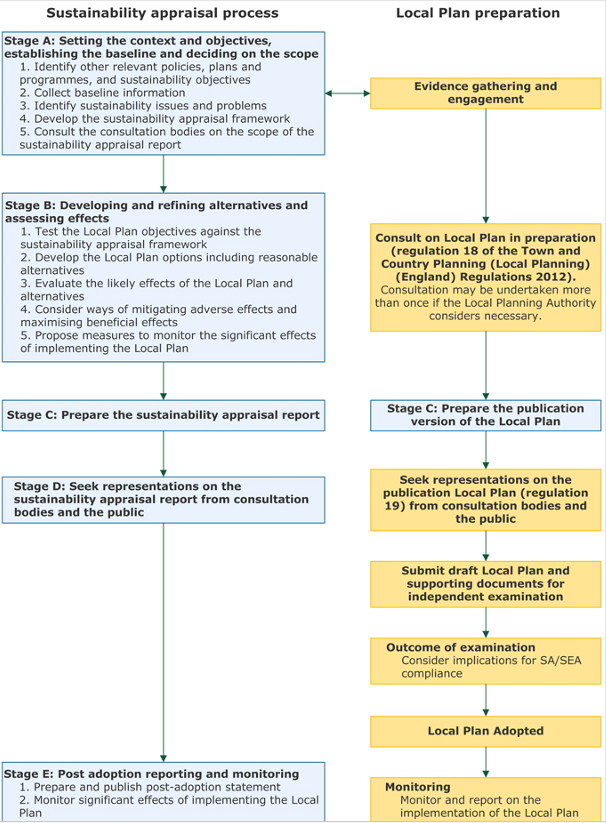
- Reviews other relevant policies, plans, programmes with a view to establishing whether their contents will need to inform the contents of the North York Moors National Park Local Plan (Task A1 in Figure 1 below and covered in Appendix B);
- Looks at what we know about the North York Moors National Park at the moment so we can know which key issues need to be addressed. In sustainability appraisal terms. This is known as ‘baseline information’ (Task A2 and covered in Appendix C);
- Identifies any particular issues and problems, using the information we have collected (Task A3);
- Sets out the objectives we will be using to carry out the sustainability appraisal and how the appraisal will be carried out (Task A4 );
- Sets out how we will start to monitor the plan to see if it is working (Task A5 and covered in Appendix D).
Guidance
This report has been drafted in accordance with guidance contained in The Planning Advisory Services ‘Good Plan Making’ Guidance available on their website. The following diagram, (taken from this guidance) shows how sustainability appraisal and plan-making should ideally fit together. This document represents ‘Stage A’ of sustainability assessment within this diagram:
| Sustainability appraisal process | Local Plan preparation |
|---|---|
Stage A: Setting the context and objectives, establishing the baseline and deciding on the scope
| Evidence gathering and engagement |
Stage B: Developing and refining alternatives and assessing effects
| Consult on Local Plan in preparation (regulation 18 0f the Town and Country Planning (Local Planning) (England) Regulations 2012). Consultation may be undertaken more than once if the Local Planning Authority considers necessary. |
| Stage C: Prepare the sustainability appraisal report | Stage C: Prepare the publication version of the Local Plan |
| Stage D: Seek representations on the sustainability appraisal report from consultation bodies and the public | Seek representations on the publication Local Plan (regulation 19) from consultation bodies and the public Submit draft Local Plan and supporting documents for independent examination Outcome of examination Consider implications for SA/SEA compliance Local Plan Adopted |
Stage E: Post adoption reporting and monitoring
| Monitoring Monitor and report on the implementation of the Local Plan |
Where are we now? Influences on our plan
Task A1 - Other Plans and Programmes
Our first task is to identify the relationship of the new National Park Local Plan to other relevant plans and programmes at international, European, national, regional and local levels (see Appendix B). This remains under review and will continue to evolve in light of consultation feedback and as the sustainability appraisal process progresses.
The general messages from this review, compared to the last time a Local Plan was produced are:
- A strengthened emphasis, since the previous Local Plan review, on measurable biodiversity net gain and nature recovery, driven by the Environment Act 2021, Environmental Improvement Plan 2025 and the newly published North Yorkshire and York Local Nature Recovery Strategy — supporting a distinct, ambitious biodiversity SA objective rather than treating nature recovery solely under a general 'natural environment' theme.
- A national growth agenda, including much more ambitious targets on housing growth.
- A sub-regional growth and rural housing agenda — via the Combined Authority, its Rural Action Plan and emerging Spatial Development Strategy — that will need to be reconciled with the National Park's statutory purposes and the 'Sandford principle' through the Sustainability Appraisal's testing of housing and economic options.
- A clear and continuing basis, through the Management Plan, for the Local Plan's overarching responsibility to conserve and enhance the National Park's natural beauty, wildlife and cultural heritage, which should remain the organising principle of the Sustainability Appraisal Framework.
- The need to maintain consistency with adjoining authorities' development plans and the Minerals and Waste Joint Plan, and to reflect cross-boundary arrangements.
Policies, plans and programmes which will have the greatest influence on our forthcoming plan (and which it will need to be in line with to be considered ‘sound’ at independent examination) are considered to be:
The National Planning Policy Framework (NPPF) and accompanying guidance
- The NPPF is the main expression of Central Government’s planning policies;
- It contains a presumption in favour of sustainable development which must be enshrined within Local Plans;
- The expectation is that plans will meet the ‘objectively assessed’ need for new housing, unless restrictions continue to be needed to be made to protect the National Park landscape;
- The NPPF recognises that development may need to be restricted where policies relate to national landscape designations such as National Parks;
- The NPPF seeks the promotion of sustainable transport, the need to grow and diversify the rural economy, the need to address and adapt to climate change, the need to avoid areas of flood risk and the need to protect and enhance important wildlife habitats and the historic environment;
- It requires that great weight be given to landscape considerations in the National Park and that proposals for major development within it are refused unless there are exceptional circumstances in the public interest.
English National Parks and the Broads – UK Government Vision and Circular (DEFRA, 2010)
The Circular is the main government policy document specifically relating to National Parks. It seeks the following outcomes:
- A renewed focus on achieving National Park purposes;
- Leading the way in adapting to and mitigating climate change;
- A diverse and healthy natural environment, enhanced cultural heritage and inspiring lifelong behaviour change towards sustainable living and enjoyment of the countryside;
- Foster and maintain vibrant, healthy and productive living and working communities;
- Working in partnership to maximize the benefits delivered.
The Circular also sets out the National Parks will work towards the delivery of affordable housing and that National Parks are not suitable locations for unrestricted market housing development.
The Environment Act 2021
The Environment Act 2021 (and associated regulations 2024) sets statutory targets for nature recovery across four priorities: air quality, biodiversity, water quality and the reduction of waste. It also sets targets to reduce the decline in species.
The Levelling Up and Regeneration Act 2023
The Levelling-up and Regeneration Act 2023 (LURA) sets out the direction for planning, making provisions to support the levelling-up agenda. It seeks to streamline the planning process, including through a reform of existing SA/SEA, Habitats Regulations Assessment (HRA) and Environmental Impact Assessment (EIA), which will eventually be replaced by a simpler process known as 'Environmental Outcomes Reports'. However, secondary legislation is required to introduce the new regime and at present the requirement to undertake SA/SEA remains in force.
The LURA also contained an enhanced duty on relevant authorities to ‘seek to further’ National Park purposes at Section 245.
The North York Moors Management Plan
The Management Plan is the overarching plan which drives all activities that have an influence on the future of the National Park. It was prepared and agreed following extensive consultation and input from residents and stakeholders with an interest in the National Park. It is therefore imperative that the new Local Plan contributes effectively to delivery of its vision.
The Management Plan also identifies the ‘special qualities’ of the National Park which must be preserved. These special qualities are wide ranging in nature and capture those attributes of the National Park which make it special, distinctive and worthy of protecting.
The North York Moors Landscape Character Assessment (LCA)
The Landscape Character Assessment (2021) identifies and describes the variation in the character of the landscape and explains the unique combination of elements and features (characteristics) that make the National Park landscape distinctive. It also identifies key opportunities and threats to the landscape.
The North York Moors Nature Recovery Plan
The North York Moors National Park Nature Recovery Plan outlines the actions required to restore and enhance nature across this iconic landscape. Structured around eight themes, it addresses vital habitats and ecosystems, with each theme including a vision for the future, clear priorities, and a series of actionable steps.
Other development plan documents
The Helmsley Local Plan 2015 (jointly prepared with the former Ryedale District Council) aimed to provide sufficient land for a mix of housing which meets the existing and future needs of the existing population, providing opportunities for managed growth of the town over the plan period, whilst safeguarding and enhancing the landscape of the National Park.
The Whitby Business Park Area Action Plan, November 2014 (jointly prepared with the former Scarborough Borough Council) aimed to make Whitby Business Park a more attractive destination and facilitate expansion of the site to support Whitby’s role as an employment centre and to provide more employment opportunities in the town.
The Minerals and Waste Joint Plan for North Yorkshire, York and the North York Moors National Park (2022). This sets out strategic and development management policies for minerals and waste development, including policies of continuing relevance to issues arising in the National Park.
Local Plans in adjoining areas
It is good plan making to make sure that any cross boundary issues which require the attention of more than one planning authority are identified early on and addressed. Issues could include accommodating new housing, strategic transport corridors or new employment development. Relevant Local Plans are:
(The 3 plans will be replaced by the new North Yorkshire Local Plan on which work is now commencing).
The Redcar and Cleveland Local Plan
Where are we now? The baseline
Tasks A2 and A3 – Collection baseline information and identifying sustainability issues and problems
To plan properly we need to fully understand the place for which we are planning. The next stage is to look at the ‘baseline’ information we have, to help identify the key sustainability issues currently facing the National Park.
This section provides an overview of baseline information. It is split into environmental, social and economic sections to reflect the grouping of the objectives we set out later in this report. It also includes commentary on any areas where information was difficult to come by or unclear. Information in this report is taken from a wide range of sources, including the 2021 Census. More detailed information of the baseline for the sustainability appraisal is set out in Appendix C. A summary of the main messages we can draw from our initial analysis of the baseline information is as follows:
Environmental issues
- The landscape of the North York Moors is especially valued, and indeed is the main reason for its designation as a National Park. It is a significant natural resource available to everyone for recreation and relaxation. It is also vulnerable to change, both from natural process but also from changes to the built environment and other anthropogenic influences such as climate change;
- The special qualities of the National Park go beyond its intrinsic landscape value. We need to continue to ensure that aspects such as tranquillity and the National Park’s dark night skies, can be maintained, or improved if possible. The North York Moors is an especially tranquil place, as measured through analysis by the CPRE carried out in 2007. Although this data has not subsequently been updated, the restrictive development policies applying across the National Park suggest that tranquillity remains an important and valued characteristic of the area.
- Recognition of the value of the dark night skies within the National Park led to the area being designated in 2020 as an International Dark Sky Reserve, one of only a small number of such designations globally;
- Water quality in the North York Moors National Park is very important in supports some scarce habitats and species. Data on water quality is from the Environment Agency’s Water Framework Directive (WFD) Cycle 3 classifications of 2022 (Source: Natural England). Classification is not annual and updated data is awaited from the Environment Agency (expected 2027). 31% of river water in the National Park is classified as ‘good’ (243 km out of 792 km). The overall figure for waterbody condition has been calculated by counting the number of waterbodies in each classification. Of all 95 waterbodies counted within the National Park (groundwater, lakes, transitional and coastal waters (TRAC) and waterbody catchments), 22.1% were classified as ‘good’, of which one was groundwater and 20 were waterbody catchments (which include rivers). 48.4% of waterbodies were classified as ‘moderate’, 17.9% were ‘poor’ (3.2% were 'bad' and 8.4% have no status or were not assessed);
- Information on soil quality is limited. No grade 1 or 2 land (high quality for food/plant production) lies within the North York Moors and due to its upland nature the very large majority of the National Park is Grades 3 to 4. There are therefore no major sustainability issues in terms of its quality as a food production resource within the National Park itself. However, soil remains a highly important resource as a carbon sink, meaning peat restoration projects and agri-environment schemes aimed at soil retention will help to benefit a wider population;
- Air quality in the National Park is relatively good but is subject to influence by activities occurring outside of the National Park. There is one identified Air Quality Management Area within the National Park, as a result of particulate emissions from domestic heating. Emissions from road transport h ave been reducing in recent years. We need to continue to ensure that air quality is maintained or improved;
- Climate change may bring particular challenges. Key issues include risk of flooding of infrastructure (buildings, roads, footpaths) and direct impact on habitats, flora and fauna; drought and water resource considerations, and also productivity; changes to the coastline as a result of a combination of sea level rise, increased rainfall and increased storminess; increased risk of fire on the moorland; changes to conditions for biodiversity which may result in loss of some species and an increase or the introduction of others, potentially threatening, species; changes to native woodland, including tree species and ground flora (and economic implications in relation to timber production); risk of heat stress can impact on more vulnerable residents of the National Park;
- Flood risk and minimising the impact of flooding is also very important. Environmental management in the upper catchments of a river can play a key role in water storage and minimising flood risk downstream as demonstrated through schemes such as ‘Slowing the Flow’ in Pickering;
- The National Park is a ‘nature hotspot’ and contains a wealth of both designated and non-designated habitats and many protected and non-protected species, much of the area is a Special Protection Area or Special Area for Conservation;
- The condition of our Sites of Special Scientific Interest has been improving over the past few years. There has also been a large increase in the amount of land managed in line with conservation objectives since 1992 although this has decreased slightly over the last year or two as a result of wider changes to national land management programmes;
- The North York Moors has a high concentration of ancient woodland;
- There has been a decrease in the number of some moorland wader birds, however populations fluctuate;
- There are no significant current issues around water supply in the North York Moors (although note earlier reference to potential climate change impacts) but information suggests that there could be increasing constraints over the timeframe of the Plan;
- The National Park has a very rich and diverse historic environment including, by far, the greatest number of Scheduled Monuments of any planning authority in Yorkshire. There has been a small decrease in the number of historic assets at risk;
- There is a reliance on areas outside of the National Park for any aggregates used in the Park, reflecting the importance of National Park designation as a constraint to this form of development;
- A significant amount of underground potash resources are being exploited and a major new potash mine is under construction in the National Park;
- Supply of local building stone is important for maintaining the built heritage of the National Park;
- Waste is dealt with mainly outside the National Park boundary;
Social issues
- The population of the National Park is currently relatively stable after a decline in previous years;
- The population in the NYMNP area is ‘older’ than other areas, including in comparison with the national position;
- Data appears to show that the rate of loss of population within the 30 to 64 age range, and the rate of increase in the population aged 65 or more have grown over the successive 10 year periods 2001 to 2011 and 2011 to 2021;
- Around 30% of all households are one person households – this percentage has been rising since 2001. This figure is nevertheless slightly below the national average;
- Compared to national and regional rates there are more households with no children;
- Despite a relatively stable population the number of households has increased – this is because households are getting smaller in size. This may have implications for future requirements for appropriate housing;
- Although up to date data is limited, the total size of the housing stock in the National Park appears to have remained broadly the same since 2011; although there has been a significant increase in second home ownership;
- Outright ownership very substantially exceeds the national and regional rate and rental via the local authority is very substantially less. This may largely reflect the relatively older population within the National Park;
- There has been an increase in the number of rights of way classed as easy to use since 2014.
- Traffic levels in the National Park have fluctuated; although data is limited there appears to have been a slight increase over the past few years;
- Car ownership levels are above county level and national rates. The car is by far the most used mode of transport within the National Park;
- Most primary schools in the National Park are running below capacity, with some having less than 50% of their capacity enrolled.
Economic issues
- Compared with the national and regional position, the National Park has a lower proportion of population who are economically active, particularly those in full time employment. Conversely, the National Park has a higher proportion of population engaged in full or part time self-employment. The relatively high proportion of the population who are not economically active is accounted for mainly by those in retirement;
- There is a very low unemployment rate, meaning there is very limited available labour to support additional employment growth within the National Park;
- Median household incomes in the National Park are below the national average;
- The population of the National Park is better qualified than other areas; however, data on the age distribution of population suggests there is a loss of younger qualified people from the North York Moors;
- The number of businesses registered in the National Park has declined slightly in recent years. Most businesses have less than 10 employees, indicating the importance of the small business sector in the National Park economy;
- There has been a decline in the number of people employed in farming in recent years. Livestock numbers (with the exception of pigs) have also declined.
- The National Park’s employment profile unsurprisingly shows a relatively high dependence on jobs likely to be catering to demand from tourists, namely wholesale and retail jobs and accommodation and food services. Employment in human health, social work and education is also relatively common and agriculture is also known to be important;
- Tourism is highly important to the economy of the North York Moors. In 2024 there were approximately 9.03 million tourism visits, an increase of 0.7% from 2023. Approximately 1.84 million visitors stayed in accommodation in the area;
- There is considered to be a fundamental link between the quality of the environment of the National Park and the success of the related tourism economy.
- 55% of our housing completions in recent years have been on previously developed land. This is an increase over the preceding 10 year period;
- Major development in proximity to the National Park boundary has the potential to impact on its setting and related special qualities. Proposals for major renewable energy infrastructure in the adjacent Vale of Mowbray are of relevance to this issue.
Sustainability issues
A summary of the key sustainability issues arising from the information identified in Tasks A1 – A3 is set out below:
Environmental
- Ensuring that the natural environment and landscape is conserved and enhanced and that National Park special qualities relevant to landscape, including tranquillity, dark skies and a sense of remoteness are maintained or improved;
- Air, water and soil quality should be maintained and improved, particularly where it is needed to support key species and habitats;
- There is a need to reduce the causes of climate change and to ensure measures are in place to adapt to its effects;
- Biodiversity and geodiversity assets need to be conserved and enhanced;
- Ensuring that the built and historic environment is conserved and enhanced;
- The need to travel by private car should be reduced;
- The most efficient use of land is required, including the optimum use of brownfield sites;
Social
- All people should be able to access services and facilities, including health, education and recreation and access the countryside;
- Housing which is affordable and to meet local needs should be provided;
Economic
- Measures should be in place to support the growth and diversity of the local economy;
- Tourism and recreation should be supported where they lead to the appreciation of the special qualities of the North York Moors National Park and help improve access for all.
Where are we going? Appraising our plan
Task A4 – Developing our sustainability appraisal framework
Next, we devise our appraisal framework. This provides the template for describing, analysing and comparing sustainability implications of the Local Plan, and testing policy and site alternatives. Guidance suggests that the framework should consist of objectives, the achievement of which should be measurable using identified indicators. The framework should be informed by the review of plans and programmes and the identification of sustainability issues and problems, which was undertaken under Tasks A1, A2 and A3.
The draft sustainability objectives set out below were initially established as part of the scoping process for the Sustainability Appraisal of the Local Plan, adopted in 2020. They were subsequently refined for the sustainability appraisal for the North York Moors Management Plan, adopted in 2022. We have now further reviewed and amended these objectives to derive a consolidated and manageable list reflecting the most up to date baseline data available. In doing so we have also taken account of the objectives set out in the Government’s 2010 National Parks Circular.
The Sustainability Objectives
Our proposed sustainability objectives are set out below. One or more ‘prompt’ questions are also included alongside each objective, to help with assessment of potential new local plan policies and site allocations against the objective. These questions are not intended to provide a comprehensive basis for assessment against the objectives but provide a steer on some of the key considerations that might be relevant.
These objectives have been generated specifically to allow us to appraise the plan. The new Local Plan will include a separate and distinct set of objectives which will be framed specifically around what that plan is aiming to achieve, and in doing so they are likely to be more ‘area specific’ than those generated for plan testing purposes.
Appendix A sets out how appraisal against these objectives will comply with the range of topics we are expected to appraise against under the SEA Directive and Regulations.
The assessments will apply relevant criteria according to each objective, however each will follow a common format:
These objectives have been generated specifically to allow us to appraise the plan. The new Local Plan will include a separate and distinct set of objectives which will be framed specifically around what that plan is aiming to achieve, and in doing so they are likely to be more ‘area specific’ than those generated for plan testing purposes.
Appendix A sets out how appraisal against these objectives will comply with the range of topics we are expected to appraise against under the SEA Directive and Regulations.
The assessments will apply relevant criteria according to each objective, however each will follow a common format:
Environmental objective E1: To maintain and enhance the quality and character of the landscape of the North York Moors, including the special qualities of remoteness, tranquillity and dark night skies
- What is the capacity of the landscape to accommodate development of the nature addressed by the policy or site allocation according to the Landscape Character Assessment, tranquillity mapping and baseline information on dark skies?
- Will the policy or allocation site lead to the coalescence or expansion of settlements which will impact on their character and setting?
- Will the policy or allocation erode the sense of remoteness in more remote areas of the National Park?
Environmental objective E2: To protect and enhance water, soil and air quality, and reduce pollution, and improve efficiency of water use.
- Would the policy or allocation be likely to have an adverse impact on a Groundwater Source Protection Zone or cause discharge into a river?
- Would this site allocation re-use and clean up a contaminated site?
- Would the policy or site allocation support the retention of soil resources and/or an improvement in soil health?
- Would the site potentially adversely affect an Air Quality Management Zone or lead to worsening air quality issues?
Environmental objective E3: To reduce the causes of climate change and ensure future development is resilient to the effects of climate change, including reducing the impact of flooding and coastal erosion and avoiding flood risk.
- Would the policy or site allocation support a shift towards the greater use of renewable or low carbon energy and/or increased energy efficiency?
- Would the policy or allocation help avoid inappropriate development within an area identified as being at risk of flooding?
- Is the site within an area prone to groundwater flooding?
- Would the policy or allocation lead to excessive demands on the water resources available to support the needs of the site or development?
Environmental objective E4: To maintain and enhance conditions for biodiversity and geodiversity and avoid irreversible losses or damage to designated nature conservation sites, protected species and geological assets.
- Would the policy or site allocation potentially affect an area designated for its habitats or biodiversity? (including SPAs, SACs, Ramsar Sites, SSSIs, SINCs, LNRs and RIGs)?
- Would the site allocation lead to a loss of established tree cover or hedgerows which would be impossible to replace in the short to medium term?
- Would the policy or site allocation lead to a loss of or damage to a geological asset?
Environmental objective E5: To conserve and enhance the historic environment, heritage assets and their settings and to help facilitate opportunities for greater access to and understanding of the historic environment.
- Would the policy or site allocation impact on historic areas and assets of interest (Conservation areas, Listed buildings, SAMs, Areas of Archaeological importance, Registered Historic Parks and Gardens) or their settings?
Social objective S1: To foster and maintain vibrant local communities and encourage a sense of community and belonging.
- Will the policy or site allocation contribute to the loss of important community facilities?
- Will the site allocation be located in a settlement with a village hall and/or pub or other form of community asset that would help further this objective?
Social objective S2: To provide decent housing in accessible locations to meet the needs of local people, including the young and elderly, and to maximise opportunities for provision of affordable housing.
- Would the policy or site allocation support the delivery of an appropriate mix of housing to meet needs arising in the National Park?
- Is there evidence of need within the settlement?
- Is the site or development capable of providing affordable housing (subsidised, cross subsidy or rural exceptions?)
Social objective S3: To protect and enhance access to community facilities, leisure and recreation opportunities and access to the countryside.
- Will the policy or site allocation protect or support the delivery of improved access to community facilities?
- How far away is the site allocation from the nearest shop or post office?
- How far away is the site allocation from the nearest School (primary or secondary)?
- Would the policy or site allocation site help enhance access for all to the National Park countryside and/or help further understanding of its special qualities?
Social objective S4: To make sure new development is easily accessible to essential services, to help reduce the need to travel and minimise the environmental impact of transport.
- Would the policy or allocation contribute to the delivery of improved access to essential services?
- How far away is the site allocation from the nearest public transport access point (bus or train station with a daily service to a larger settlement)?
- How far away is the site allocation from the nearest right of way or cycle route?
Economic objective EC1: To strengthen and diversify the local economy by supporting a range of opportunities for employment and training particularly in sustainable locations.
- Would the policy or site allocation contribute to the loss of an employment or training facility?
- Would the policy or site allocation support or lead to additional employment of a nature compatible with National Park purposes and special qualities?
- Would the policy or site allocation support economic and community resilience through improvements to communications infrastructure and provision of opportunities for home working?
Economic objective EC2: To support the tourism and recreation industry by ensuring that development contributes to the local economy in a manner compatible with National Park purposes and protect or enhances opportunities for understanding and enjoying the Park’s special qualities.
- Would the policy or site allocation result in the loss of a tourism facility?
- Would the policy or allocation lead to improved access to or availability of recreational and tourism facilities in the National Park for all residents and visitors?
- Would the policy or allocation protect or enhance National Park purposes and special qualities?
These objectives have been generated specifically to allow us to appraise the plan. The new Local Plan will include a separate and distinct set of objectives which will be framed specifically around what that plan is aiming to achieve, and in doing so they are likely to be more ‘area specific’ than those generated for plan testing purposes.
Appendix A sets out how appraisal against these objectives will comply with the range of topics we are expected to appraise against under the SEA Directive and Regulations.
The assessments will apply relevant criteria according to each objective, however each will follow a common format:
- Positive impact: consistent with meeting the objective, either by having no negative impact or by positively influencing change in accordance with the objective.
- Negative impact: Will hinder achievement of this objective.
- Neutral impact: Will have a neither a positive nor a negative impact upon this objective.
- Uncertain impact: May hinder achievement of this objective, but may have no negative impact, or may have a positive impact. This will depend upon implementation.
- No direct link: There is no direct link with the objective.
In addition, the nature of the effects will be considered in terms of whether they are:
- Direct or indirect;
- Permanent, long term (i.e. more than 15 years), or short term (less than 5 years); Scale – are they local or wider in geographical extent?
Sustainability Appraisal should identify the cumulative and significant effects upon sustainability objectives. The assessment of cumulative effects will involve looking at the effects upon each sustainability objective in turn. This assessment will then assist in determining whether there are likely to be any significant effects. Consideration will then be given to whether any mitigation of effects can be woven into plan policy.
Monitoring
Task A5
As part of the production of the new Local Plan the Authority will also be reviewing the indicators that are monitored to check that they are still relevant and whether new ones need to be included. All new policies in the Plan should be capable of being monitored over time to make sure the Local Plan is working as originally intended. As a starting point Appendix D includes an initial set of monitoring indicators for the objectives we have set out. These will be used as a source of information to help us understand the sustainability effects of the options we consider as we carry out testing on the Local Plan.
Monitoring of the Local Plan will be reported in the Authority’s Annual Monitoring Report or Authority Report.
Next Steps
Consultation will be undertaken on this Scoping Report for 8 weeks during September/October 2026 with the three Statutory Consultees (Heritage England, the Environment Agency and Natural England) and other relevant organisations. It is not considered appropriate to undertake a wider consultation at this stage due to the technical nature of the Scoping Report. Any comments received will be considered in finalising the Scoping Report.
As the Local Plan is drafted, the framework established by this Scoping Report will be used to undertake the Sustainability Appraisal. Initially an assessment will be undertaken of the strategic options which will help to inform the selection of the overall strategy. Following this, an assessment will be carried out on the objectives and policies of the Plan as they are drafted, as per Figure 1. The Sustainability Report will be published alongside the draft Local Plan as part of the public consultation.
If you would like further information, please contact us:
Planning Policy – policy@northyorkmoors.org.uk
Last updated: 26 Oct 2026